APR 16 2001
By Win Goodbody
At the end of leg 6 we reached McLeod, MT and then, via car, Bozeman, MT.
This was the halfway mark for our Yellowstone traverse. We had traced a
nearly uninterrupted route from South Pass, just below the Wind River Range
near Lander, WY, all the way to I-90 in southwestern Montana. The
northbound half of the trip actually ended up being easier than expected,
partly because low snow mandated some route changes that kept us below more
difficult terrain. Still it felt great to reach Bozeman and get ready to
turn south toward the sun. Only another 300 or so miles to go.
Though it is not as tightly hemmed in as Jackson, WY, Bozeman sits
surrounded by numerous mountain ranges. The Gallatins, our target for leg
7, start just south of town and run for 70 miles all the way into
Yellowstone Park. Unlike the Absarokas, the Gallatins offer a uniformly
high, relatively mild crest route. We aimed to follow it as far as we could
before exiting through the Park toward West Yellowstone, MT.
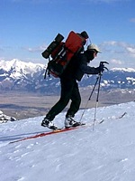
Hyalite Canyon was our entrance to the mountains, and by day 3 we had
reached Hyalite Peak. The weather was perfect with just a slight breeze as
we skied down the rocky summit slope toward the start of the crest. The
first few miles were the hardest. With a large cornice overhanging the lee
side, the safest place to be was in the trees on the scoured windward side �
in this case the west side, about 50 yards below the top. The surface of
the snow was uneven and deeply carved into channels by the wind. The going
was slow indeed.
Avalanche danger, which we hadn�t really faced hardly at all so far this
year, was now an issue. New snow had been piling up in steady, small
infusions over the last week. As we sidehilled along our skis sliced off
small sloughs. Below us the slope steepened considerably. Then we noticed
cliffs. Once we had to take our skis off and posthole straight uphill
through bottomless, rotten junk to avoid crossing a deep ravine. We camped
at Crater Lake that night.
The Gallatin Crest offers stunning views in all directions. To the east is
Paradise Valley where the Yellowstone River, now much larger than the
mountain creek we had followed on leg 4, makes its exit from the high
country toward Livingston, MT. Beyond the river the jagged Absarokas rush
up. To the west is the Gallatin River, and just beyond the Madison Range.
To the south is Yellowstone National Park. It�s harder to think of another
vantage point from which one can see more of Greater Yellowstone at one
time.
For the next two days we continued south. The weather was unsettled and
windy. Dark clouds trailed snow into the valleys on both sides of us, but
it wasn�t too bad right on the crest. Day 5 was a breakthrough. The crest
flattened and we skied up and down long, broad ramps, covering as much
ground in a few hours as we had in an entire day back on the steeper parts.
Now a real storm set in, however. Heavy snow. We made camp at Windy Pass.
The next day the storm was still going strong. Strange, but the spring we
thought was on the way only a week before was now nowhere to be seen. In
fact full winter was the case. We decided to stay put and spent the day
skiing nice powder on low angle, treed slopes. Without the weight of our
packs, moving was a delight. Climbing uphill after a run, I felt like I was
being pulled by a t-bar lift. I was reminded that on a great day in a great
place, there is nothing like skiing.
The storm dropped over a foot of mysteriously heavy snow. Trail breaking
the next day was a chore, and our previously heroic pace was now closer to a
standstill. We weren�t going to be able to cover the rest of the crest into
Yellowstone Park at this rate. It was now day 7 and we had only brought 10
days of food. We were maybe halfway through this leg. Time for an escape
route.
We found it west of the Fortress, where Buckhorn Creek drops to the Gallatin
River. It looked like it would only be about 7 miles, and a trail the whole
way. Sure enough, not only were there trail blazes as soon as we hit the
woods, but those magical signatures of civilization that always lead to a
trailhead: snow machine tracks.
Coming down, we saw fresh bear tracks all along the trail. At one point one
set of very large prints along with one set of very small prints thrilled
our imagination. We certainly didn�t want to interrupt mamma bear�s
leisurely stroll with junior. In two hours we were out, hitching north to
Bozeman to retrieve our car.
[ Top ]