12 MAR 2001
By Win Goodbody
Thorofare Creek. Two Ocean Pass. Atlantic Creek. Yellowstone Point. Open Creek. To hunters from around the world these are more than just names of geographic features in northwest Wyoming's Teton Wilderness. They are legendary places renowned for abundant wildlife in the most remote area of the US's lower 48 states. The closest road is 30 miles distant. Right next door is Yellowstone National Park. For those who know some part of the thousands of square miles of rugged terrain here on either side of the Park border, the area is simply "Thorofare." Inside this one word fits the very heart of Yellowstone country, the distilled essence of everything that is great about this crown jewel of America's natural heritage.
"Despite all of the usual problems that will have an impact on Thorofare's future, this is still a staggering swath of relatively undisturbed earth where, to paraphrase the Wilderness Act of 1964, '...man is a visitor who does not remain.'"
Thorofare really refers to two main drainages that grow from steep mountain creeks into larger rivers that meander through flat, wide valley bottoms before merging. Each drainage is initially tight and dense, spilling down between rocky Absaroka peaks, but then broadens and opens into vast meadows etched with old oxbows where waterways shift back and forth. The Thorofare Creek drainage starts on the north face of Younts Peak near the Continental Divide and heads north before turning west. The Yellowstone River drainage starts on the south side of Younts and goes west before turning north.
These two rivers wind around opposite sides of the massive Thorofare Plateau and then join just before entering Yellowstone National Park's southeast corner. It seems odd that the river downstream of the confluence is called the Yellowstone, for before they meet Thorofare Creek looks larger than the Yellowstone River. From this point the Yellowstone flows north into the Park until it hits Yellowstone Lake, some 15 miles away.
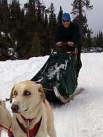
Thorofare hosts the bulk of its human visitors during one concentrated period each year. Every autumn in those parts of Thorofare outside the Park, hunters arrive to pursue elk, moose, deer, and other game. Whether or not they are in harmony with the letter or, more importantly, the spirit of the law, there are in fact many permanent hunting camps scattered throughout Thorofare and the Teton Wilderness, and it is clear that hunting is big business.
Miniature towns spring up as large groups with convoys of horses hauling in everything needed to live well for weeks on end. The more developed camps feature raised platforms, log furniture, corrals, and enormous 50-gallon steel drums in which food is secured from bears. Though there are usually ample numbers of animals to hunt outside the Park, guides and outfitters will place salt licks just beyond the Park boundary in an effort to lure creatures out and ensure that paying clients have something to blast away at.
Other people, far fewer in number, come to hunt with camera and binoculars, either in summer or fall. For them, just being in Thorofare and feeling the pulse of this magnificent land is sufficient payback for the long journey in. Here are also to be found animals that cannot be hunted, such as wolves and grizzly bears. Despite all of the usual problems that will have an impact on Thorofare's future, this is still a staggering swath of relatively undisturbed earth where, to paraphrase the Wilderness Act of 1964, "...man is a visitor who does not remain."
All told, several thousand people might pass through during the annual window of milder weather. But for more than half the year, from early November until early June, no one comes. With the first real snowfall, the backcountry falls quiet and the last humans decamp for town. A visit to Thorofare in winter is therefore a chance to experience real isolation and behold Yellowstone's unique beauty during a harsh season.
This was the fourth leg of our Yellowstone traverse and a return to longer distance travel. The second and third legs of the winter had each been half as long as the one before (the first leg was 130 miles, the second was 60, the third was 35). We had to break out of this pattern, I realized, or we would soon be down to day trips of several hundred yards. A trip into Thorofare was just the thing to turn our attentions back to longer miles and more challenging territory. We figured it would take two weeks to cover the 80-mile route we had plotted.
Remote in summer, Thorofare is even harder to reach when snow is on the ground. Approaching from the south, it's 30 miles through wild Absaroka territory. Continuing from where we left off at the end of our last leg through the northern Gros Ventre Range, we depart from Togwotee Pass in unsettled weather. Scattered snow showers swirl around in a black sky. After several sunny days in town, which I used mainly to sit inside and eat too much, it looks like we are at last due for some snow.
Amazingly, Togwotee Pass is the first road running east-west across the Continental Divide in Wyoming that we have come to since starting our trip 200 miles to the south almost two months ago. We will cross only one or two more roads between here and the northern turnaround point of our traverse at Bozeman, Montana. Heading north from Togwotee feels a little bit bleak, even if we do have a groomed road to follow for the first few miles. We're really leaving civilization behind and going deep into the woods this time. Or so we think.
Five miles on, a stunning old wooden lodge appears. Built in 1922, it stands on the original highway to Yellowstone and was the stopping point for many illustrious personalities back in the day. In more recent years, I had heard from someone, it was a basic backcountry lodge where you could stay or eat. Just a nice place to stop in. We ski hungrily to its door, drawn by full-blown fantasies of one more night inside, one last meal before being forced back into our pathetic floorless tent (it's all we've brought this time) where we live on dehydrated beans and sticks of butter.
Sadly, Brooks Lake Lodge has turned into an upscale if barely patronized outfit of late, a way station for private snowmobile tours. The local henchman materializes instantly and removes us from the bar before we can even inquire what's on tap or find out if any of the paying guests want to put some money on a game of billiards. I ask whether, by any chance, there's some unheated back hallway in employee housing where we could maybe curl up in our sleeping bags for the night? The response is as warm as a mid-February night in Yellowstone: No can do. We decide to retreat just beyond the fascist compound's perimeter to erect our shantytown for the night. It's now snowing in earnest.
It's hard to explain the kind of magnetic appeal these last outposts of humanity exert on me as we leave on a trip. It seems to be getting worse as the winter wears on. Each leg is just a little harder to embark on. Each departure day (especially if the weather is dark) seems a little grimmer. I feel I am looking for a reason, any reason, to put off for one more day the inevitable wilderness death march that is sure to come. Any diversion at all to hang us up. To be rebuffed at the lodge when comfort is so close seems unbearable. I'm just not ready to crawl into the sleeping bag again. I almost want to shell out the $150 for a night indoors.
And it's not just major, obvious pitstops like a lodge in front of my skis that make me want to postpone the inevitable. Outward bound on our drives from town to trailheads now, every little gas station we pass suddenly looks like a great place to stop and explore. They might have precious local gifts we can find nowhere else. They might sell those orange hats that say, "My wife thinks I'm hunting!" I need one of those. Or maybe a piece of petrified wood with "Wyoming" emblazoned on it. Definitely need one of those in the pack. And I must get another road atlas for my collection.
Any kind of establishment that has anything for sale must be investigated. Look over there! Don't we need a 300 pound chainsaw wood carving of a moose head? What, to take with us? Can we stop at this bathroom? We just stopped 15 minutes ago. I know, but I don't want to miss one. Should we stop for lunch here? We already had lunch. Twice. I know but...we may never eat again. Whoa there! A point of historical interest! Can we stop and read about how trapper Bucky nearly starved to death at this very spot 150 years ago and had to resort to eating the leather from his snowshoes? We really shouldn't. Hits too close to home. Plus it's getting late. That's exactly the point, I think. If I can just stall for another hour or two we may have to wait another day before casting off. Like sand slipping through my fingers, the few remaining opportunities for frittering away time vanish into the air. The trailhead is getting dangerously close now. Doesn't look like there's any way out.
Wait! Turn this car around! I can't leave without knowing who won the match between the Jersey Penguins and the Hoosiers! I try to disguise my inadequate knowledge of pro sports by keeping the references vague. Leave off a city name here, the full team moniker there. I'm sure as heck not going to risk mentioning a specific sport by name. Cast the net wide, I think. Better chance of getting something. Could be baseball, basketball, hockey, Australian football, or cricket I'm talking about. Jersey might mean New Jersey, or maybe I'm off in Britain following a darts tournament. Have to keep Joe guessing.
There must be a pro sport game going on somewhere in the world at this moment. And I have to know the outcome! I'm hoping cricket. Don't those things go on for days? We can't leave now, not when Sri Lanka might be trailing Norway by hundreds of points or baskets or yards or whatever they have in that game. Come on Sri Lanka! No dice. A last whimpering claim that I've forgotten my stock car racing magazines and can't go forward without them does nothing to slow the car down. The trailhead looms. I'm being delivered to my doom with no delay.
The morning after being denied our civil rights at the Brooks Lake Lodge, we awake to more snow. Not what I was hoping to see. It's coming down. Not really dumping, but steadily snowing. We may have a few inches from the night. This is the first real accumulation from a storm we've seen this winter, and it has an immediate effect on our mood. Before I'm more than three words into the sentence I've crafted to subliminally convince Joe that maybe we should stay put and see what the weather does, he practically shouts his assent to the plan. Apparently we're on the same wavelength. It's the first rest day we've taken on the trail, the first day we haven't packed up and kept moving no matter what. The very thought of sitting around drinking endless cups of tea and reading sounds like heaven to me. And then there is the lodge with roaring fireplaces and gourmet food just across the way. We vow to take a second shot at infiltrating the posh resort.
It turns out the lodge is open to the public (read: unwashed masses) for lunch, so we slink over and decide to pay way too much for a fabulous four course meal. The fact that we are now actual customers parting with dollars and not marauding visigoths (for the moment) keeps the welcoming committee from last night at bay.
I still feel like there is a closed circuit camera pointing at our table and burly guards in an underground command center watching our every move, but for the moment everything is okay. Here it is day two and Joe's having the mushroom fettuccine while I demolish the linguine with cream sauce. Our only concern is the size of the portions, but we figure this isn't the usual "all you can eat" joint we're accustomed to and that a request for "some more" wouldn't be well received.
Now that we've taken the financial hit, we decide to get our money's worth. We have justified the significant outlay for lunch as tickets to a day indoors (the snow continues to fall). Even though the restaurant closes at 2:30pm, we hang around and play pool in the bar. Then we settle in with some magazines and try to strike up a conversation with the bartender. Maybe we can find some common ground that will lead to an invitation to stay inside tonight. Doesn't happen. I watch him periodically out of the corner of my eye to see if he's whispering into some tiny microphone on his lapel, reporting back to the command center on our whereabouts.
Come 5pm Joe is still inside by the fire, reading and smiling at every staff member who passes by. They seem to be appearing with some frequency, maybe to check whether he's still there. He's doing his best to look like a legitimate overnight patron, but they're not buying it. They're probably trying to decide which of several different lodge security forces should be tasked with removing him.
Meanwhile I've reached my shame threshold and have gone outside for a ski around the lake, not wanting to be present for the inevitable hands-on eviction that will occur as soon as our goon friend from last night returns. Sure enough, around 6pm Joe is formally asked to leave. He goes without a fight and heads back to the tent to inform me of the defeat.
As much as we might want to, it's pretty clear by now that we are not going to be spending the rest of the winter at Brooks Lake Lodge. I don't even think we can get away with our seven hour lunch scam again. I'm picturing an all-out offensive by the authorities to remove us from the immediate area (and maybe Wyoming) starting first thing in the morning if they so much as catch a glimpse of us. We have to move.
Our choices are to turn around and ski the five miles back to the road where we'll start hitchhiking south to Mexico and a sunny beach, or to push on. We decide on the latter and saddle up on the morning of day 3. We're Absaroka bound. Not a peep from the lodge as we head across Brooks Lake. I look around half expecting to see artillery pieces on surrounding peaks swiveling towards us, trained and ready just in case we change our minds and try to head inside again.
But the layover was not a total loss. Far from it. In fact, the poor weather motivated us to consult our maps for the first time and see exactly what we were getting into. It was a bit of a wake up call. We seem to be in the habit of planning most sections of our trip on very large scale maps. Restaurant place mats of Wyoming, road atlases, maps of the US hanging in drug stores, globes of the earth: all of these have at one point or another been the research tool of choice for plotting our way through Greater Yellowstone.
The only problem with these topographic specimens is that they yield none of the low-level detail necessary to actually navigate day by day. What ends up happening is that the night before we leave on a leg (assuming we have had the foresight to get our hands on a quad or other smaller scale map) we sit down to examine how we might actually get through wherever it is we are heading. Suddenly the landscape is full of cliffs, avalanche slopes, gorges, and dense woods.
It's sort of like tracing a finger across a map of Arizona thinking it might be a fun hike, then realizing you just crossed the Grand Canyon. What looked pretty straightforward on the map of Wyoming that flashed across the TV screen during an evening weather report now looks downright impossible. These are usually quiet moments as we each pore over the maps and realize that there is no way we can go where we thought we could.
Spreading out all our quad maps on the table in the lodge after lunch (I glance nervously at the bartender to see if this breach of decorum might prompt a call to the command center), we get a rude shock. There is no way we are going to be able to follow the Continental Divide north from Brooks Lake to the headwaters of Thorofare Creek as was our plan. The Divide here is a featureless plateau above treeline, and getting on and off would require crossing steep slopes. With this year's poor snow conditions, not to mention the storm that was currently unloading, it would be plain foolish to head up there. Plus we don't have a real tent, and our experience on Island in the Sky during leg two has already filled my annual quota for traveling (not to mention camping) on exposed plateaus in high winds during whiteouts.
It's as if there is a blackboard in front of us with our route chalked on it. We get out the eraser and wipe the slate clean. We have to rethink the entire thing, or at least the first half. We notice there is a low route option. It winds around and follows drainages where the Continental Divide route is straight, but there are no dangerous slopes and it stays mostly on valley bottoms.
We hadn't thought of going this way before because of dreadfully dense woods and the potential for out of body bushwhacking experiences, but now we see there are trails we could follow. It might not be too bad. Yeah, I've heard that one before. Without much discussion, we mentally draw the new route up on the board. We're happy about it. It feels like a huge relief now to know that we aren't going off to be sacrificed to the weather gods. The optimism about our new route more than offsets any bad feelings from the Brooks Lake Lodge affair, and we set off excited and energetic. I am raring to go and don't want to return to town anymore.
For two days we hack our way toward the South Buffalo Fork drainage. The going isn't great; we see some of the same bottomless, collapsible junk we've come to expect and love, but we are moving forward at least. By afternoon of day four we arrive at a hunting camp on the side of a large meadow below Pendergraft Peak. In a low snow year such as this it is very easy to spot these camps, some more elaborate than others. The site of crude log structures and a large metal drum inspires us to make ourselves a home away from home.
We dig a large rectangular pit down to the ground and gather wood for a fire. In an hour we are as comfortable as one could be, in or out of town. There are some large trees above us, and even though snow is falling we are sheltered. We stoke the fire, gaze out into the Absaroka night, and enjoy a break from the brutal cold that has followed us on past legs. One of my favorite rationalizations is that it can't be brutally cold if it's storming, and vice versa. So the good news tonight is that it isn't brutally cold. Because it's storming.
The next morning, after more consulting with the maps, we make the second major change in our route. As snow continues to fall and we look at the area around Younts Peak on the quad (for the first time, of course), we notice what a perfect avalanche slope our route crosses. No way to avoid it. This is where we planned to get over the Continental Divide, which runs along the spine of the high Absaroka crest in this area. Worse, we notice that the trail on the other side of the Divide up Thorofare Creek stops before the head of the canyon. There are several miles between where we would pass Younts Peak and pick up the trail on the valley floor below. Hmmm, I wonder why that is?
If there is anything I have learned so far this year, it is to STAY ON THE TRAIL! I have told Joe I will pay him $50 for every time I suggest leaving the trail as long as he hits me with a shovel and prevents me from actually doing it. If there is a trail through an area, there is a reason for it. And if a trail stops somewhere, you can be darn sure there is a reason for it. After all, people have been traveling through these parts for hundreds, even thousands, of years. It's highly unlikely that all the nice routes through haven't been found already. Adventurous off-trail exploration in a place like the Absarokas certainly has its place, but not when you're trying to make good time with heavy packs in February.
Examining the tight spacing of contour lines on our quad map, I see that the upper Thorofare drainage near Younts Peak looks like prime habitat for some of my least favorite species, namely cliffs and gorges. I also suspect there are healthy local populations of downed trees and impenetrable brush lurking in there. Our experiences leaving the trail along the Green River during leg one and then again coming down Redmond Creek during leg two have left too much emotional scar tissue to ignore. I don't want to do it again. I picture us rappelling with packs using the shoelace, our 120-foot section of 8mm chord. No thanks. Afraid that a descent of the upper Thorofare would use up our lifetime quotas of world-class bushwhacking and canyoneering, we decide to nix it.
But we then see there is another way over the Divide with a trail the whole way. Instead of going north from Younts and then west (following Thorofare Creek) toward the massive meadows where Thorofare Creek and the Yellowstone River meet, we can go west and then north (following the Yellowstone River). I'm disappointed we are abandoning Thorofare Creek, but the idea of descending the Yellowstone River almost from its source (which, as for Thorofare Creek, is Younts Peak) is thrilling. A few minutes spent with the map and we are once again excited and happy with this change of plans. There is no question it's an easier route, also a little bit shorter.
All these breakthroughs in planning and navigation, and it's not even 9am! Meanwhile, as we realize the route just got easier and shorter, and notice snow is still falling on and off, and feel the warmth from the morning fire we have going at possibly the best camp site either one of has ever enjoyed in winter, what do we decide to do but take another day off and stay put! We're getting used to this rest day thing now. It's so easy to do. You simply wake up and announce you're not going anywhere and then go back to sleep. Again, I am the first to verbalize the concept, unsure whether Joe is going to think I have gone completely soft. The second rest day and it's only day five?! Instead he responds as if I've just offered to carry his pack the rest of the trip. A rest day it will be then. Back to the fire. Once again, we are both thinking the same thing.
We spend the day lounging, reading, and collecting enough wood for a massive bonfire. Before this winter, I had only experienced one fire on an overnight ski trip, and that was in June. As I had never done it much before, I never thought of making fire a part of the daily winter camping routine. If you had asked me about having a fire in winter before this year, I probably would have said it was a lot of trouble and not worth the effort. But that was before I went ski touring with Joe Hartney.
A veteran of not one but several courses on tracking and outdoor skills taught by my fellow New Jerseyan Tom Brown, Joe knows what he's doing out here. Thank God one of us does. I increasingly feel like I am playing client to Joe's guide. When it comes to fire, Joe leaps into action like a dynamo. He can have a blaze going in no time and seems to instinctively set about gathering wood the moment we make camp, much as I grab the shovel and start excavating a hole for our tent. After seeing how easy it is to get one going in the right conditions, I am now a winter fire convert.
A fire in winter is nice anytime anywhere, but in the Absarokas right now conditions are so fire-friendly that it is almost foolish not to have one. Like much of the west, the Absarokas are still bone dry after the active fire year in 2000. All the fuel that did not burn is still right there under a few feet of snow. Actually the Absarokas themselves did not ignite much this past year, but they could have. Literally all you need to do to start a fire is brush the snow off a piece of wood and hold a match to it. It's astonishing how dry it is. You can hold a match to boughs on a dead tree and ignite the entire canopy. Past blazes killed many trees but left them standing. They now fall down all over the place. There are huge quantities of partially burned trees on the ground. It takes little effort to find and collect them. Possibly the best thing about winter fires is that you can have them in places you never could in the summer. Whereas in current conditions a summer bonfire in South Buffalo Fork would set Wyoming on fire, in winter it's perfectly safe and manageable.
We leave our hunting camp on day six, and even though we have spent almost two days there doing nothing but eating and roasting next to the fire, it's not easy to pack up. The weather remains spotty and we know we're long overdue for a pummeling. But everything we own is dry and we are fully rested and beyond well fed. Building on the obscene amount of food I consumed during the last stint in town, I have continued to eat like it's the end of the world and now feel a little sick. I almost have to force myself to eat dinner just to keep the weight reduction program for my pack going, but in truth I'm no longer hungry. I guess there are worse afflictions I could be suffering from in the backcountry.
Having gone as far as possible up the South Buffalo Fork, we're ascending Lake Creek toward the Continental Divide now. We have to go up and over to hit the Yellowstone River, and we pray for a decent weather window to see us through. We've made all the route changes we can at this point. There's no way to avoid this high crossing.
The first day going up is pretty good. There are so many trailblazes on so many trees we may as well have a set of runway lights guiding us along. We don't even have to pay attention to follow the trail. We get some sun splashes but no real views that paint a picture of the route ahead. Can't really see where we're going up above. That night it clears up, which brings back the cold. Down to around -20°F but we're doing fine.
The next day we get going early and things look good initially. We approach within a mile or two of Ferry Lake, almost to the Divide. All the snow that's been falling over the last few days is really adding up now. We're glad we don't have to face that blank Younts headwall in what are surely terrible avalanche conditions. It's deep powder. It would be great skiing, but we're breaking trail through it.
A few hundred feet above Ferry Lake is a mild pass over the Divide that will deliver us into Woodard Canyon, at the bottom of which we will hit the Yellowstone River, our highway for the rest of the trip. Once we reach the Yellowstone, all route-finding and weather issues will be done as it's flat ground on the trail the rest of the way. Even if it's a raging storm we will be in the trees and can slog along okay. I am looking forward to that moment even though I know we are sure to hit some terrible snow down there. I'd rather face the bad snow demon than be way up here waiting for the Blizzard of '01 to kick in.
But it will have to be another day that we find out what Woodard Canyon looks like. Quickly, thoroughly, the weather turns evil. It's snowing and blowing, and visibility deteriorates. We can't actually see Ferry Lake, but we know it must be there in front of us. We leave the trees to start plodding up toward the lake and get a taste of the wind. It's not an Island in the Sky gale, but still humming along all the same. We can't see a thing. We blunder around for an hour and, incredibly, are still not sure where the lake is. This is a decent-sized alpine lake, and the fact that we can't find it doesn't bode well for tracking down the pass above. We take cover in a clump of wind-blasted trees to figure out a plan.
I know Joe wants to go up and over regardless. I'm not that concerned about finding the pass. We can get out the compass and start flying blind if it comes to that. It's more the question of what descending Woodard Canyon in the maelstrom will be like that has me worried. Whereas we can put it in reverse, retrace our steps, and still find our way back to treeline and a feasible campsite on this side of the Divide, once we go through the pass we're just on our own in the whiteout with no knowledge of what lies ahead.
The voice of fear and paranoia prevails, and I convince Joe that retreat sounds pretty good right about now. We turn tail, and though it's not been more than 25 minutes or so since we entered the stand of trees, our tracks have been erased by the wind. We just took it as a given that our tracks would be there as an umbilical chord for at least a few hours or so in case we wanted to go back, but they're gone. We eventually find them by probing around for a more supportable strip of snow through the white and manage to feel our way along.
We make it back into the woods by mid-afternoon and set up the tent behind a massive tree that shields us almost completely from the wind. Time to wait. The storm rages on. It's Saturday, and I realize a good friend is having a no-holds-barred 30th birthday bash back in Portland, Oregon, this very night. The theme is Saturday Night Fever. What I wouldn't give to be there. Instead, I'm stuck here singing songs from the soundtrack. The names of several of them such as "Night Fever" and "Staying Alive" seem rather appropriate given our situation. From Joe's scowl I can tell I'm not the only one wishing I were elsewhere.
We get our window the next day. It isn't clear, but we can see the lake, and once we reach it we can see the pass. And then it does clear, or at least on the east side of the Divide. What we see confirms a half-baked weather theory we have been working on the last few days. Coming up the South Buffalo Fork we have had some real snow, but we have also had nearly continuous light flurries as something frozen — not snow — falls from the air. It's more like tiny pieces of frozen vapor. This happens all the time, even when skies are clear. It's almost like any moisture that is in the air, even if there are no clouds, is being squeezed out.
Given the local topography, this makes sense. The Continental Divide here is a high mountain crest above 10,000 feet, and all weather moving west to east gets pushed up over this massive obstacle. With the lifting, the moisture has no choice but to come out. Once we are at the pass and can see both sides of the Divide we are given a stark piece of visual evidence that seems to support the theory. To the west, the South Buffalo Fork is a sea of clouds while to the east down Woodard Canyon, it's a clear, sunny day.
Descending Woodard Canyon is a joy. The upper reaches of the drainage are so open we can just cruise along effortlessly. I have taken up the call I championed toward the end of leg one in the Wind River Range that "it's all downhill from here." While technically true, it's also almost 45 miles to the road. Joe strips his climbing skins off his skis and makes a few turns in perfect powder. As we get into the woods we find more of the manic trailblazes everywhere. We lose the trail maybe once or twice while crossing open avalanche chutes but quickly rediscover it. I have started to photograph these trail blazes. I want a collection of them. What could be more welcome to the eye of a ski tourer in the Absarokas than big, fresh trailblazes? We are really getting lucky with this one. Before we know it the downhill stops and we are standing on the bank of the upper Yellowstone River.
It seems hard to believe, but we have penetrated to the inner sanctum. How did this happen? The moat has been crossed, the turret guards sacked, doors broken down, inner courtyards laid waste, maidens rescued from towers. We are there. We have battled our way through to the most remote place in the lower 48 states. And it wasn't even that hard! We listen as our shouts of joy echo crazily up into the canyons. I cringe to think how enraged the local weather gods will be when they wake up and see that we are already over the Divide and deep into the promised land. Nothing they can do about it now. Too late to throw the Blizzard of '01 at us. Sorry guys. Maybe next time.
I almost want to cry. It feels indescribable to be here at last. The Yellowstone River in February! Thirty-five miles upstream from Yellowstone Lake! It seems so wild, so quiet, so alive, so free, and so far away. It's a vision that could sustain decades of wilderness ski touring. Just the thought that one day I might stand right here could get me through anything.
Steep-sided cliffs and slopes of burned, thin trees plummet down on all sides. It feels massive, an ocean of wilderness. There are animal tracks everywhere. The river itself is not very wide yet. After all, we are only a few miles downstream from its origin on Younts Peak and it's just getting going. But there is no mistaking that with a little care and feeding and a few hundred miles of flow, this little whippersnapper is going to grow into one of the great rivers of the Northern Rockies. We stand and gawk. The weather is lovely and late-afternoon color starts to paint the scene. This is one to remember.
Eventually we snap out of our stupor, somewhat sobered by the realization that even if we have made it this far we still have a long way to go. We continue along the trail (more blazes) for another hour before making camp. We can just about see the opening ahead where the river veers north into a broad meadow. We'll surely reach it tomorrow. Joe builds a small fire from burned downfall and we settle in for a cold, clear night.
Day nine dawns perfectly clear and still. A savage cold hangs in the air. The weather gods know that their snow machine is now more or less useless as we are out of the mountains and can keep going in just about any storm conditions. But maybe they can slow us down or at least make life just a bit uncomfortable with their cold machine. Either they got a brand new turbo-charged model for Christmas or some ace mechanic has given the old one a complete overhaul. The results are impressive. It's in the -25°F range, which we've seen before, but this just feels really, really cold.
Joe and I leave the sleeping bags and immediately start doing the cold weather war dance. This consists of jumping, hopping, running in place, swinging arms and legs, blowing on fingers, anything to keep the blood flowing. The dance is an awkward enterprise to begin with, and the fact that the snow is completely unsupportable at our campsite doesn't make things any easier.
You can't just roam around anywhere as one step on any snow we haven't painstakingly packed down will result in a thigh-deep plunge. Not what we need right now. We've each sculpted our own little platforms and stand watching each other flop and twist. Talking at this point is strictly forbidden, aside from the occasional obscenity or prehistoric grunt. Tra la la! Ah, Yellowstone!
Even as we plow into the normal morning routine of making breakfast and breaking camp, the dance must continue. This makes for a haphazard on-again, off-again kind of progress that would probably be humorous to watch if we weren't living it. Everything happens in fits and starts. You can't get out your stove, light it, and start melting some snow in one continuous process. By that time your hands would be frozen solid. You have to do one little thing, then rewarm. Do the next little thing, then rewarm.
As it so happens, the cooking area we hastily set up the night before is wedged against the fire pit. There's not much room for dancing in there. But dancing is mandatory, so I frantically pioneer a new traveling variation going back and forth between the cooking area and my platform. I go and set up the stove. Hands are now numb, so I head back to the dance platform, careful to only step on the few packed footprints that will support my weight on the way. Swing, hop, jump, blow, shake. Now there's some feeling so it's back to light the stove.
Into the fire pit. I fill the stove's primer cup with fuel. Where's the lighter? I start searching zipped compartments in my jacket. Damn zippers. Can't really operate them with gloves on. Not in that one. Hands are heading south fast. There's the lighter. It's in a Ziploc bag. Struggle to open it. [ATTENTION! HANDS WILL BE FROZEN HARD AS WOOD IN 10 SECONDS!] I'm getting an alert from the engine room that I should head back to the dance platform, but I just want to get the damn lighter out at least on this run. Ziploc won't open. [BEGIN COUNTDOWN! 10, 9, 8...] Got the lighter out! May as well try to start the stove while I'm here. [7, 6, 5...] I flick it. Nothing. Shake it. [4, 3, 2...] I take off my glove to work the lighter with my bare hand. Boy, is it cold. It won't light, though it now feels like my hand is on fire. Too late. [...1! ABORT! ABORT!]
I cram my useless limb back in the glove and hobble over toward the dance floor. In my haste to get there I miss one of the packed footsteps. It's as if I stepped into space. I plunge in to my thigh, and as I wasn't expecting this at all and am caught completely off guard, I fall face first into the snow. Getting up isn't easy because, again, there's nothing to push solidly on to right myself except the packed spots, which have now been obscured by my floundering. It's a full snow bath as I thrash around in the white stuff. Joe seems to be enjoying this.
At last I get up. I pull my submerged leg out of the posthole, but my camp bootie catches and remains lodged three feet down. My socked foot comes out on its own and is instantly ice cold. I balance on my one foot that has a bootie, not wanting to have to step into the snow with my sock but pretty sure that's going to happen. Somehow I get the wayward bootie back and put it on. On to the dance floor at last for some super charged disco movements. Time to get funky.
And so the morning goes. The sun hits camp at about 8:30am and the temperature leaps. We realize part of the trouble is that we've camped in a classic cold air sink right next to the river bottom. It's taken longer than usual this morning to activate the 40- or 50-degree temperature swing we've come to expect. It's going to get up to 25°F today. As we warm up, we wonder what all the fuss was about.
This is the day we make it out into the open. After several hours on the trail, we reach the burned fringes of the first of several large meadows along the upper Yellowstone. The snow has been mixed, alternating between supportable and rotten junk. Through the burn, it's not too bad. We're actually covering ground. Late in the afternoon when we try to head straight across the first open swath of flood plain we find out what bad snow is all about.
It's thigh-deep junk. Each step goes right to the ground. We have to lean back on our skis to keep tips up lest they snag in the ample bushes. We're snowshoeing, postholing on skis. The pace is excruciatingly slow. Looking behind us it appears we have shoveled a three foot deep trough through the meadow. We're submarining along, still about 20 miles from Yellowstone Lake (and from the Lake it's another 15 miles to the road) and have five days of food left. At the speed we are going now we could easily run out of food before we make it out. Our spirits, previously sky high, turn morbidly dark.
Reaching the north side of the meadow, we decide to call it a day and resort to our favorite anti-depressant to lighten things up: fire. Joe starts hauling in entire trees. I begin excavating an enormous rectangular area for the fire and our camp. The snow is three feet deep, but I outline a 12 foot by 20 foot area and start digging. An hour-and-a-half later we have ourselves an amazing pit beside a beautiful meadow. It is quite possibly the greatest campsite ever. And the sun is still up. Our moods swing 180 degrees again and we enjoy a long night of stoking the fire and eating. It's such a beautiful night, we decide to just sleep out under the stars in our giant pit. It's going to be another cold one.
I wake up at 3:30am. My feet are going numb. I wish I had left a stove set up next to me so that I could cook a hot water bottle to put in my sleeping bag but I forgot. I'm conscious of a fiendishly powerful force that seeks to strip any warmth I have accumulated in my bag. It's horrendous. Much too cold to even get up and try to put on more clothes or get warmer. I huddle and fiercely rub my feet together for the rest of the night. I don't fall back asleep. This is all part of being admitted to the inner sanctum, I say to myself. The good news is that it isn't storming. Because it's brutally cold.
Joe probably interprets my getting up at 7am to build a fire as a weird sign. Something must be up. He's done about all the fire building so far. I just gather wood. But here I am out of the bag breaking sticks and stacking them in a pyramid. I have waited as long as I can, and it's now light out. I need to get warm and I know this is no ordinary morning. Not a cloud in the sky and dead calm. But it's colder than usual. I can feel it. Before I even consult my little key chain thermometer I am fully prepared to swear that this is the coldest temperature I have ever experienced. I just know it is.
When I check the thermometer it's doing something I've never seen before. Whereas we are used to seeing it maxed out at -25°F or so, there is always a little bit of the red column protruding up from the ball at the bottom. Just a tiny bit, but enough to see that there is a slight rise above the ball. I always assumed that this was the max, that no matter how cold it got the thermometer would always look the same. I actually wished I had a better thermometer that went lower just so we would know exactly how cold it really was.
But this morning there is no red column above the ball. I look closely because it's such a slight difference I could be wrong. But there is no mistaking it. Only the ball is red. Nothing above it. In my dementia I imagine that even some of the ball is empty. Yikes. I estimate by some mystical and completely unscientific method that it is at least -35°F. We later find out after exiting that on this morning it is -30°F at West Thumb on Yellowstone Lake. We are slightly higher than the lake but more importantly we are in a massive cold air sink with steep walls on all sides. It could well be even colder than -35°F where we are.
Joe gets up and samples the brisk morning air. It's too cold for the war dance. We have to get a fire going pronto. We opt for a "hot start" and splash stove fuel on the wood to speed things up. Even white gas is a little ornery at this temperature and requires an open flame applied for several seconds to get a response. But once coaxed over the initial hump, it goes like crazy in no time. We spend the next two hours sitting very close to a raging fire. When the sun comes up it feels like a blow torch. We spread our sleeping bags out to thaw, and steam boils off of them. It's the first real drying sun we've had this winter. Despite the inhuman cold, I know that spring is on the way
For the next four days we continue down the Yellowstone River heading for Yellowstone Lake. Just beyond our camp with the swimming pool-sized fire pit, the snow mysteriously turns supportable and we begin to fly. Each day our packs are lighter. The cold relents and it's so hot during the afternoons that Joe takes off his shirt. Animals are everywhere. We're just another two beasts roaming the valley floor (which is now several miles across). We might even smell worse than most of the other ones around. On these final days we hit our stride. This is what we came for. It's about the most enjoyable time one could have on a wilderness ski trip. I don't want it to end. For the moment, Yellowstone is ours.
Mighty Thorofare Creek comes in from the east. We'll have to come back another time to explore that universe. We hit the southern boundary of Yellowstone National Park. Not far now. We see wolf tracks. They've just been here ahead of us. We spend a day skiing past The Trident, a peak I've wanted to see for years. We're in the home stretch, almost to the lake. Colter Peak goes by. We can see the lake. We arrive at the blank expanse of snow and ice, welcomed by two bison who look like they've been postholing as much as we have this year. The Southeast Arm of Yellowstone Lake.
Day 13. It's the last day to the road. We have something like 17 miles to ski to get to Lake Butte near the northeast end of Yellowstone Lake. That's where the groomed road from the East Entrance comes in. I know we'll be able to find a ride there around to the South Entrance, and from there we'll hitch another ride back to Jackson, our home base.
We take off like Norwegian nordic racers on the most supportable snow we've seen. We can even kick and glide and are really going for it. The weather is sitting on the fence at first. Looks like maybe the snow machine is sputtering into life, but then it dies. Must be out for maintenance.
As we watch, Yellowstone Lake appears out of the clouds and we can see everything. All the way across. We see The Promontory, Frank Island, Dot Island, even West Thumb. This is my Park! We have talked about maybe trying to ski right across to West Thumb but are wary of open water. We stick to the eastern shore and rip past one point after another.
By early afternoon the day has turned into a keeper. It's sunny with hardly any wind. And we are loose on Yellowstone Lake like a bunch of criminals. Just having the time of our lives. We stop briefly when trading leads, otherwise it's heads down hammering. But this is not a death march. This is pure joy. We feel invincible and want to see what we can do. After a winter of going slow, we want to push it home. The smell of the barn is overwhelming now. We can taste the finish line. And it's only 3pm!
Sometime after rounding Park Point I glimpse Steamboat Point in the far distance. I recognize it and know where the road comes in. It can only be a few miles now. After passing Elk Point I start to go flat out. The movement feels good. I don't know how long I can keep it up, but I'll stick with it for now. Joe sees that it's still about four miles to go and has the sense to maintain a normal pace.
I can't even feel my pack. Either I've done permanent spinal damage and have lost all feeling in my shoulders or I've learned how to pack light at last. Kick and glide! I can't believe I've been missing this all those years I spent skiing on fixed-heel gear! The snow hisses by. Home stretch now. One more small bay to cross and that's it. I can see the road cut ahead. I feel like I could get airborne with a little more effort. A thundering final burst sees me to the line.
That's it. I'm there. I slide to a stop. All the cold, all the bad snow. It's all been wiped away by the last four days. I want to start shouting. We made it! Yellowstone, my Yellowstone! Thorofare! I can't even think, and luckily there is no need to. Joe comes in and we stand there resting. Then it's time to go ashore. Just in time for a glorious sunset across the lake.
Luck is with us and we get a ride out first thing in the morning as we had hoped. Driving back to Jackson, my thoughts race over the great landscape we have passed through. There are so many more trips to do, so much more to learn. But for a first-time visit to Thorofare, we've done pretty well. Not only did we get to the place itself, we got to the very heart of its spirit.
[ Top ]