13 FEB 2001
By Win Goodbody
Joe and I were in good spirits after the first leg. It was a perfect opener
to our winter in Greater Yellowstone. Despite the brutal cold and a
marathon exit day, it was, on the whole, an enjoyable time.
Perhaps it was too
enjoyable. After almost five days back in town mending gear, mind, and body,
we departed for our second leg in the Gros Ventre Range with a cavalier
attitude. Though we had budgeted 10 or 12 days for this traverse, we now
thought it might take only a week. But we were wrong. Instead of a walk in
the park, the Gros Ventres were a lesson in how slow and difficult progress
can be when the weather turns bad. We were sternly reminded that, in
adverse conditions, the mountains hold all the cards.
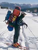
"I felt like a backpacker's version of the Joad family, whose members fled
the Dust Bowl with all worldly possessions hanging off their battered truck."
We traded sleds for packs on this 60-mile trip from Cora to Jackson. It had
been a long time since I carried a full pack, and somehow I forgot there was
a world of difference between pulling and carrying weight. Joe wisely
trimmed down as he set out what he was bringing. Imagining more stellar
sunrises and sunsets ahead, I was determined to tote the same 20 pounds of
camera gear I had with me on the first leg. Big mistake.
As we hefted our loads and pulled away from the car, I knew I was in
trouble. My pack towered over Joe's. I could just barely lift it off the
ground. It looked like I was setting off for months. In addition to
filling every cubic inch of interior space, I had so many items lashed to
the outside. I felt like a backpacker's version of the Joad family, whose members fled
the Dust Bowl with all worldly possessions hanging off their battered truck
in
The Grapes of Wrath. I was to fare about as well on this trip as the
poor Joads did in Steinbeck's bitter novel.
Good weather persisted as we made our way up Rock Creek to the high crest
that runs continuously from just east of Bondurant all the way northwest
past Jackson to Slide Lake and the Gros Ventre River. We had hardpacked
snow machine tracks to follow for the first two days. On day four, approaching
the first pass by Hodges Peak, we got a taste of world-class wind.
There is a good reason why Wyoming is a prime site for development of
wind-generated power we learned. Like the cold on the first leg, wind was
to be our constant companion on this trip. It raged through the gap,
knocking over full water bottles left standing on the snow during a break.
Luckily, the air temperature was mild, or we would have been turned
into frozen statues.
After traversing around the west side of Doubletop Peak through worsening
visibility, we emerged into clear, calm air and a stunning sunset. We had
not known ahead of time whether we would be able to get through a gap between
two sets of cliff bands. If not, it was going to mean dropping a
few thousand feet into a steep drainage we would then have to climb back out
of a mile or so farther along.
But the gap went through easily, and we
turned the corner to find ourselves staring at a classic multi-tiered rock
shelf that stretched away for two miles toward our next pass. The red glow
of evening coated sheer walls above us as we made camp among giant boulders.
"Everywhere we went, we heard the snow collapse. Cracks ran in every direction."
We were now solidly up on the Gros Ventre high route. On the map, it was
amazing how little actual distance remained between us and Slide Lake, the
terminus of this section. We had simply to cross a high basin, another
drainage, and then follow a high plateau to Sheep Mountain, from which it
was "all downhill."
The wind was blowing hard as we passed Palmer Peak the next day and set our
sights on the Crystal Creek drainage. A little while later it was blowing
really hard. We couldn't tell whether the snow flying horizontally past us
was falling from the sky or being stripped off the ground, but, either way,
visibility was poor. We went nonstop for a few hours to get off the exposed
high basin where the Gros Ventre River originates.
Descending Crystal Creek, we took our skins off and skied at a pleasant pace
through nice powder snow to the valley floor. As we went lower and got out
of the wind, we could see that it was indeed snowing. There was
about a foot of new snow on the ground. Up higher, the wind kept
snow from accumulating and sculpted what little coverage there was into a
rock-hard surface, while down here in the still, densely treed valley, the snow was
deep and light.
That night, we cheered ourselves by digging out a large shelter for our
floorless cooking tent. The Megamid is a pyramid tent that sets up easily.
After digging a square pit several feet down, you erect the tent with one
center pole and have a large, warm area to sit in. Sheltered from the wind,
we were very comfortable and drank cup after cup of tea and cocoa as we
consulted the map and assessed the route ahead. We hoped to wake and find
blue skies. Island in the Sky, the plateau that would be our highway for
the remaining five or six miles before we descended toward Slide Lake, was not far
away.
The storm wasn't over the next day, but it had stalled a bit. We moved down
the valley through deep snow and then started to climb up an adjacent fork.
Dense woods slowed us to nearly a standstill. By nightfall, we reached
a spot where, at least in clear weather, we should have been able to see the
final climb up onto the Island. But the storm was now back on track, and as we
got higher, we could feel the first brushes of what was undoubtedly a
screaming wind up on the Island. Again we excavated a deep pit for the
Megamid and spent a warm evening inside, wondering what the weather would
do tomorrow.
The next day, the morning was almost clear. This was now becoming a pattern.
We got ourselves going and continued traversing up the side of Crystal
Creek's West Fork and headed for Island in the Sky. As we passed over steeper
terrain, we noticed how fragile the conditions had become with the additional
load of new snowfall. Everywhere we went, we heard the snow collapse. Cracks ran in every direction. Sloughs moved on even the smallest
hillsides. We hoped we would be able to find a route that did not
cross any open slopes.
By afternoon, true to form, the storm was back in high gear. Trailbreaking
was knee-deep. If film had been taken of us at this point, maybe replaying
it at fast forward speed would have looked like a normal pace. The weight
of my pack was becoming painful. My left leg had strange tingles running
down it and was slightly numb. Joe said that happened to him sometimes when
he carried a heavy pack. "Have you been carrying a heavy pack recently?" he
deadpanned.
"...just when we really needed
some guidance, we caught brief glimpses through the clouds of a ridge or
valley far below."
Despite the storm, we could see the edge of the Island. We were right at
the base of it. With only a few hundred feet of climbing, we would be on top. We were now at the head of the West Fork drainage, and as we
approached treeline, the wind increased. Though it was only 2pm, we
decided to camp and wait one more day to see if the storm would abate. If
we were going to venture up high in these conditions, we wanted to start
first thing in the morning to have a full day to make our way across safely.
For the third night in a row, we built a snug Megamid shelter.
I was awake most of that night listening to the wind and snow. I sometimes
though it was easing. But by morning, the four-day-old storm was coming on
strong. It was Day 8 of our trip. We weren't getting any breaks this time.
Knowing it could go on like this for days, we decided the sooner
we got up and over, the better.
Trailbreaking was difficult as we left the trees to negotiate a few small
cliff bands. At one point, Joe set off a little slough that moved him
downslope about 50 feet. The terrain was such that we were in no real
danger, but conditions were flashing a bright red light at us. We knew we
had no steep slopes to reckon with, so we continued on, hugging a scoured
ridge line where grass poked through the snow. Soon we were on top.
Island in the Sky is a featureless plateau that runs for three or four miles
just south of Sheep Mountain and due east of Jackson Hole. The plateau is as high or
higher than anything to the immediate west, and is thus exposed to the full
force of the prevailing wind.
As we shuffled onto this no man's land, I
felt like a bug on a windshield. The wind was shrieking. Visibility was
almost zero, and we were navigating by compass alone. I found that looking
straight down at my skis was the best way to maintain balance. Otherwise
there was nothing to see but white, and it was hard to tell whether you were
standing or falling.
We leaned into the wind with poles splayed out on either side. Sharp gusts
or sudden pauses would precipitate frantic movements as we tried to readjust
our stances. We were in the thick of it. I think we both realized the
seriousness of our position, though we didn't talk about it. Of course, we
could always retreat and wait another day, but the desire to get out was
strong. As we continued, four or five times, just when we really needed
some guidance, we caught brief glimpses through the clouds of a ridge or
valley far below. These moments were enough to figure out where we were.
After two or three hours of feeling our way, we made it to the base of Sheep
Mountain. Visibility was too low to see down the slope we thought we could
descend, so we set up our tent and prepared for a windy night.
Waking up to clear skies in a place where you went to sleep unable to see
anything is an interesting feeling. The town of Jackson was below us, and we were
eight miles from the road. It all seemed so much simpler now that we could
see.
Of course, we ended up making a wrong turn, and a six-hour bushwhack
through enormous downfall and dense woods ensued. Reminiscent of our last
exit, we staggering through darkness onto a packed snowmobile trail. A few
more miles and darned if those weren't headlights shining toward us— a friend
picking us up, and just in time. We really have to stop driving on those
trails.
Taking that weight off my back for the last time was a relief. As blood
flowed and feeling returned, I resolved to never again overload myself that
way. No more stuff hanging every which way off my phone booth-sized pack.
Never again. I would be a Joad no more.
[ Top ]